

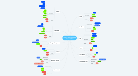
1. Planning
1.1. Applications Serviced
1.1.1. Critical Area
1.1.2. Zoning
1.1.3. Comeback Annapolis
1.1.4. Bike Story Map
1.2. Data Maintained
1.2.1. Parcels
1.2.2. Addressing
1.2.3. Zoning
1.2.4. Critical Area
1.2.5. Bike Layers
1.3. Systems
1.3.1. Energov
1.3.2. ArcGIS
2. Public Works
2.1. Applications Serviced
2.1.1. Trash
2.1.2. Utilitiy Map Services
2.2. Data Maintained
2.2.1. Sewers
2.2.2. Water
2.2.3. Stormwater
2.2.4. Impervious Surfaces
2.3. Systems
2.3.1. ArcGIS
2.3.2. Iworq
3. Emergency Management
3.1. Applications Serviced
3.1.1. ODFREE
3.1.2. Integromat Implementatin
3.2. Data Maintained
3.2.1. Overdose data
3.3. Systems
3.3.1. ArcGIS
4. Finance
4.1. Applications Serviced
4.1.1. Impervious
4.2. Data Maintained
4.2.1. Impervious
4.3. Systems
4.3.1. ArcGIS
4.3.2. MUNIS
5. Recreation and Parks
5.1. Applications Serviced
5.1.1. Park Finder
5.2. Data Maintained
5.2.1. Parks
5.3. Systems
5.3.1. ArcGIS
5.3.2. Street Names in Rec Munis Module
6. Transportation
6.1. Applications Serviced
6.1.1. Transit Applicaton
6.2. Data Maintained
6.2.1. Bus Stops
6.2.2. Bus Routes
6.3. Systems
6.3.1. Transit system
6.3.2. ArcGIS
7. Police
7.1. Applications Serviced
7.1.1. ODFREE
7.2. Data Maintained
7.2.1. Post Areas
7.2.2. 911 Addresses
7.3. Systems
7.3.1. New World
7.3.2. ArcGIS
8. Law/Clerk
8.1. Applications Serviced
8.1.1. Who's My Alderman?
8.1.2. Where do I vote?
8.2. Data Maintained
8.2.1. Wards
8.2.2. Precincts
8.3. Systems
8.3.1. ArcGIS
9. Fire
9.1. Applications Serviced
9.1.1. Water Source
9.1.2. Call Dashboard
9.2. Data Maintained
9.2.1. Fire Call Data
9.2.2. Hydrant
9.2.3. Water Source
9.3. Systems
9.3.1. ArcGIS
10. Mayor
10.1. Applications Serviced
10.1.1. EV Charging
10.2. Data Maintained
10.2.1. Hold
10.3. Systems
10.3.1. ArcGIS
11. MIT / General
11.1. Applications Serviced
11.1.1. Hold
11.2. Data Maintained
11.2.1. Hold
11.3. Systems
11.3.1. ArcGIS
12. Environmental Policy
12.1. Applications Serviced
12.1.1. Conservancy Applicaiton
12.2. Data Maintained
12.2.1. Tree Canopy
12.3. Systems
12.3.1. ArcGIS