
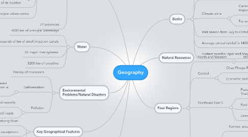
1. Water
1.1. 4000 km of principal waterways
1.2. Thousands of km of small irrigation canals
1.3. 25 major river systems
1.4. 3200 km of coastline
2. Bordering Countries
2.1. North and West: Myanmar and China
2.2. Northeast: Laos and Cambodia
2.2.1. Mekong River forms the border
2.3. Southern: Myanmar and Malaysia
3. Key Geographical Features
3.1. Mekong River
3.2. Dongrek escarpment
3.3. Malay Peninsula
4. Environmental Problems/Natural Disasters
4.1. History of monsoons
4.2. Deforestation
4.2.1. Leads to top soil erosion and increased flooding which are both big problems in Thailand
4.3. Pollution
4.3.1. Anti-pollution laws being enforced recently
4.3.2. New mass transit systems and toll roads
5. Cities
5.1. Bangkok
5.1.1. Main port
5.1.2. Central region
5.1.3. One of the most congested and polluted cities in the world
5.1.4. Capital
5.1.5. Very susceptible to flooding because of its location
5.1.6. Principle urban centre
5.2. 77 provinces
6. Basics
6.1. Area: 513,115 square km
6.2. Elevation: sea-level to 2565 m
6.3. Climate zone
6.3.1. Central and North experience tropical monsoon climate
6.3.2. Far south has equatorial climate
6.4. Wet season from July to October
6.5. Average annual rainfall is 1400 mm
6.6. Hottest months: April and May
7. Four Regions
7.1. North and Western
7.1.1. Mountainous
7.2. Central
7.2.1. Chao Phraya River Basin- very fertile
7.2.2. Economic and political heart of Thailand
7.3. Northeast (Isarn)
7.3.1. Plateau makes up 1/3 of Thailand's land mass
7.3.2. Poor soils
7.3.3. Uneven rainfall
7.4. Southern
7.4.1. Formed around two mountain ranges
7.4.2. Narrow coastal strips
7.4.2.1. Andaman Sea
7.4.2.2. Gulf of Thailand
7.4.3. Highest rainfall in Thailand