Unlock the full potential of your projects.
Try MeisterTask for free.
Non hai un account?
Iscriviti gratis
Naviga
Mappe in primo piano
Categorie
Gestione del progetto
Affari e obiettivi
Risorse umane
Brainstorming e analisi
Marketing e contenuti
Istruzione e note
Intrattenimento
Vita
ICT
Design
Sintesi
Altro
Lingue
English
Deutsch
Français
Español
Português
Nederlands
Dansk
Русский
日本語
Italiano
简体中文
한국어
Altro
Mostra mappa intera
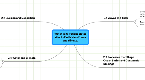
Water in its various states affects Earth's landforms and climate.
Istruzione e note
MS
Michael Schmidt
Seguire
Iniziamo.
È gratuito!
Iscriviti con Google
o
registrati
con il tuo indirizzo email
Mappe mentali simili
Schema mappa mentale
Water in its various states affects Earth's landforms and climate.
da
Michael Schmidt
1. 2.2 Eroision and Deposition
1.1. Stream Characterisitics:characteistics that describe a stream or river.
1.2. Sediments: eroded rock fragments and soil carried by water or wind.
1.3. Watershed: area of land that drains into one main lake or river.
1.4. Continental Divide:highest point of land on a continent.
2. 2.4 Water and Climate
2.1. Climate: the average weather measured over a long period of time.
2.2. Currents: smaller straems that move through bigger bodies of water.
3. 2.1 Waves and Tides
3.1. Waves:circular movement o water particles that moves along the waters surface.
3.2. Tides:daily change in water level of oceans.
4. 2.3 Processes that Shape Ocean Basins and Continental Drainage
4.1. Glaciers:large moving bodie of ice.
4.2. Seamounts: underwater volcanos thatdon't come all the way to the top.
4.3. Moraines:when rock and gravel build up at the base of a glacier.
4.4. Eskers: glacier meltwater that flows in tunnels.
4.5. Drumlins small hills with a teardrop shape.
4.6. Kettle Lake: lake formed by a glaciers melt water.
Comincia. È gratis!
Connetti con Google
o
Registrati