Unlock the full potential of your projects.
Try MeisterTask for free.
Heb je nog geen account?
Meld je Gratis aan
Browse
Aanbevolen kaarten
Rubrieken
Project management
Zakelijke doelen
Personeelszaken
Brainstormen en analyseren
Marketing & Inhoud
Onderwijs en notities
Entertainment
Leven
Technologie
Ontwerp
Samenvattingen
Andere
Talen
English
Deutsch
Français
Español
Português
Nederlands
Dansk
Русский
日本語
Italiano
简体中文
한국어
Andere
Toon volledige map
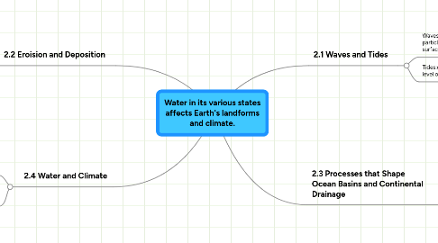
Water in its various states affects Earth's landforms and climate.
Onderwijs en notities
MS
Michael Schmidt
Volg
Laten we beginnen.
Het is Gratis
Login met Google
of
registreren
met je e-mailadres
Vergelijkbare mind mappen
Overzicht van map
Water in its various states affects Earth's landforms and climate.
Door
Michael Schmidt
1. 2.2 Eroision and Deposition
1.1. Stream Characterisitics:characteistics that describe a stream or river.
1.2. Sediments: eroded rock fragments and soil carried by water or wind.
1.3. Watershed: area of land that drains into one main lake or river.
1.4. Continental Divide:highest point of land on a continent.
2. 2.4 Water and Climate
2.1. Climate: the average weather measured over a long period of time.
2.2. Currents: smaller straems that move through bigger bodies of water.
3. 2.1 Waves and Tides
3.1. Waves:circular movement o water particles that moves along the waters surface.
3.2. Tides:daily change in water level of oceans.
4. 2.3 Processes that Shape Ocean Basins and Continental Drainage
4.1. Glaciers:large moving bodie of ice.
4.2. Seamounts: underwater volcanos thatdon't come all the way to the top.
4.3. Moraines:when rock and gravel build up at the base of a glacier.
4.4. Eskers: glacier meltwater that flows in tunnels.
4.5. Drumlins small hills with a teardrop shape.
4.6. Kettle Lake: lake formed by a glaciers melt water.
Begin. Het is gratis!
Verbind met Google
of
Registreren