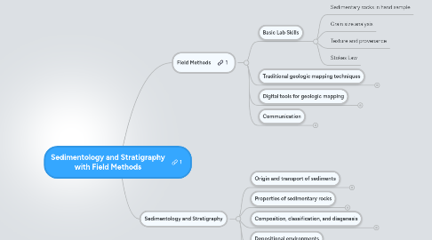
1. Sedimentology and Stratigraphy
1.1. Origin and transport of sediments
1.1.1. Weathering processes
1.1.1.1. Subaerial weathering processes
1.1.1.2. Submarine weathering processes
1.1.1.3. Soils
1.1.2. Transport and deposition of siliciclastic materials
1.1.2.1. Fluid flow fundamentals
1.1.2.2. Particle transport by fluids
1.1.2.3. Gravity flows
1.2. Properties of sedimentary rocks
1.2.1. Sedimentary textures
1.2.1.1. Grain size
1.2.1.2. Particle shape
1.2.1.3. Fabric
1.2.2. Sedimentary structures
1.2.2.1. Stratification and bedforms
1.2.2.2. Bedding-plane markings
1.2.2.3. Paleocurrent analysis
1.3. Composition, classification, and diagenesis
1.3.1. Siliciclastic sedimentary rocks
1.3.1.1. Sandstones
1.3.1.2. Conglomerates
1.3.1.3. Shales
1.3.1.4. Diagenesis of siliciclastic sediments
1.3.1.5. Provenance significance of mineral composition
1.3.2. Carbonate sedimentary rocks
1.3.2.1. Carbonate chemistry
1.3.2.2. Limestone textures
1.3.2.3. Dolomite textures
1.3.2.4. Carbonate structures
1.3.2.5. Classification of carbonates
1.3.2.6. Origins of carbonate rocks
1.3.2.7. Diagenesis of carbonate rocks
1.3.3. Other sedimentary rocks
1.3.3.1. Cherts
1.3.3.2. Carbonaceous sedimentary rocks
1.4. Depositional environments
1.4.1. Continental Environments
1.4.1.1. Fluvial systems
1.4.1.2. Glacial systems
1.4.2. Marginal-marine environments
1.4.2.1. Deltas
1.4.2.2. Beaches and barrier islands
1.4.2.3. Estuaries
1.4.2.4. Lagoons
1.4.2.5. Tidal Flats
1.4.3. Siliciclastic marine environments
1.4.3.1. Marine shelves
1.4.3.2. The deep ocean
1.4.4. Carbonate environments
1.4.4.1. Carbonate shelves
1.4.4.2. Slope/basin carbonates
1.4.4.3. Organic reefs
1.4.4.4. Mixed carbonate/siliciclastic systems
1.4.4.5. Evaporite environments
1.5. Stratigraphy and basin analysis
1.5.1. Lithostratigraphy
1.5.1.1. Lithostratigraphic units
1.5.1.2. Stratigraphic relations
1.5.1.3. Vertical and lateral successions
1.5.1.4. Nomenclature and classification of units
1.5.1.5. Lithostratigraphic correlation
1.5.2. Chronostratigraphy
1.5.2.1. Geologic time units
1.5.2.2. The geologic time scale
1.5.2.3. Chronocorrelation
1.5.3. Basin Analysis
1.5.3.1. Mechanisms of basin formation (subsidence)
1.5.3.2. Plate tectonics and basins
1.5.3.3. Kinds of sedimentary basins
1.5.3.4. Techniques of basin analysis
1.5.3.4.1. Measuring stratigraphic sections
1.5.3.4.2. Preparing stratigraphic maps and cross sections
1.5.3.4.3. Siliciclastic provenance studies
1.5.3.4.4. Geophysical studies
1.5.3.5. Applications of basin analysis
2. Field Methods
2.1. Basic Lab Skills
2.1.1. Sedimentary rocks in hand sample
2.1.2. Grain size analysis
2.1.3. Texture and provenance
2.1.4. Stokes Law
2.2. Traditional geologic mapping techniques
2.2.1. Locating yourself on the map
2.2.2. Collection and Plotting of Structural Data in the Field
2.2.3. Measuring a stratigraphic section
2.2.4. Effective use of a field notebook
2.2.5. Working with rocks
2.2.6. Creating and working with geologic maps
2.2.7. Mental concepts for the field
2.3. Digital tools for geologic mapping
2.3.1. Tools for making maps in the office
2.3.2. Tools for making maps in the field
2.3.3. Photogeologic mapping
2.3.4. GeoFieldBook
2.4. Communication
2.4.1. The traditional geologic field report
2.4.2. Making an annotated field guide in ThingLink
3. Assessments
3.1. Module content
3.2. Skills
3.2.1. Reading a ternary diagram
3.3. Laboratory Exercises
3.3.1. Stokes' Law
3.3.2. Grain Size Analysis (Seive)
3.4. Field Projects
3.4.1. Pembina Gorge
3.4.2. Cedar Creek Anticline
