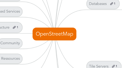
1. H.O.T
1.1. Tasking Manager
1.2. HOT Guide
1.3. Mailing list
1.4. Mumble
1.5. HOT Membership Code
1.6. HOT chats
2. Conferences
2.1. State Of The Map
2.2. State of the Map - Europe
2.3. State of the Map - US
2.4. State Of The Map - France
3. OSM Foundation
3.1. Working Groups
3.1.1. Communication
3.1.2. Data
3.1.3. Licensing
3.1.4. Local Chapters
3.1.5. Operations
3.1.6. Engineering
3.1.7. StateOfTheMap Organizing Committee
3.1.8. Strategic
3.2. Membership
3.3. License
3.3.1. Open Data
3.3.1.1. Open data Commons Open Database License (ODbL)
3.3.2. Cartography
3.3.2.1. Creative Commons Attribution-ShareAlike 2.0
3.3.2.1.1. Attribution
3.3.2.1.2. Share Alike
3.3.3. API Policies
3.3.3.1. API usage
3.3.3.2. Tile usage
3.3.3.3. Nominatim usage
3.4. Donation
4. OSM-based Services
4.1. General
4.2. Art
4.3. Biking, geocaching, hiking, sport
4.4. 3D
4.5. Routing
4.6. Compare
4.7. Edits
4.8. Accessibility for persons with disabilities
4.9. Live/real-time edits to OSM data
4.10. Quality Assurance
4.10.1. Osminspector
4.10.2. Osmose
4.10.3. QualityStreetMap
4.11. Social Networks
5. Topological data Structure
5.1. Nodes
5.2. Ways
5.3. Relations
5.4. Area
5.5. Tags
6. Community
6.1. Forum
6.2. Mailing lists
6.3. IRC
6.4. Contributors
6.4.1. Over 1 million
6.4.1.1. 50000 Active
6.4.1.2. Stats
6.4.2. Free user account
6.4.3. Carto party / Mapping party
6.4.3.1. MapCraft
6.4.4. Pascal Neis' Contributors Map
7. Learning Ressources
7.1. Learn OSM
7.2. English Learning Guide
7.3. MapTime
8. Other tools
8.1. OSM on Paper
8.1.1. MapOSMatic
8.1.2. Field Papers
8.1.3. Walking-Papers
8.1.4. OpenPaperMaps
8.1.5. OpenStreetPosters
8.1.6. Cycle.travel
9. Thanks to all © OpenStreetMap contributors. Information mostly gathered from the wiki (http://wiki.openstreetmap.org/wiki/Main_Page) and conversations at the SOTM-France 2014
10. Editing
10.1. Desktop editors
10.1.1. JOSM
10.1.2. Merkaartor
10.1.3. QGIS /QGIS server
10.2. Browser editors
10.2.1. iD
10.2.2. Potlatch2
10.3. Mobile editors
10.3.1. Android
10.3.1.1. OsmAnd
10.3.1.2. Vespucci
10.3.2. Android & iOS
10.3.3. iOS
10.3.3.1. PushPin
10.3.3.2. MapZen
10.3.3.3. GoMap
10.3.3.4. Iloe
10.4. Others
11. Getting Data
11.1. Download extract
11.1.1. Planet.osm
11.1.2. Worldwide extract
11.1.3. Regional extract
11.1.4. Global Thematic extracts
11.1.5. Geofabrik.de
11.1.6. BitTorrent
11.2. Format
11.2.1. Main
11.2.1.1. PBF
11.2.1.2. OSM XML
11.2.1.3. O5m
11.2.1.4. OSM JSON
11.2.2. Other variants
11.2.2.1. JOSM file format
11.2.2.2. OSM Binary Format
11.2.2.3. OSMbin (file format)
11.2.2.4. OSM Mobile Binary Format
11.3. API
11.4. OverPass API
11.4.1. XML
11.4.2. JSON
11.4.3. overpass-turbo
11.5. XAPI (Extended API)
12. Coding
12.1. Leaflet
12.2. OpenLayers
12.3. Mapstraction
12.4. APIs
12.4.1. Mobile Platform
12.4.1.1. Route-Me (iOS)
12.4.1.2. OSMDROID (Android)
12.4.2. MapQuest Open API
13. Databases
13.1. PostgreSQL
13.1.1. POSTGIS
13.2. MySQL
13.3. SQLITE
13.3.1. SpatiaLite
13.3.2. Geo Package
13.4. MonetDB
13.5. CouchDB
13.6. MongoDB
13.7. Schemas
13.7.1. Most used
13.7.1.1. Osm2pgsql
13.7.1.2. imposm
13.7.1.3. Osmosis
13.7.1.4. ogr2ogr
13.7.2. nominatim
13.7.3. apidb
13.7.4. osmsharp
13.7.5. overpass
13.7.6. mongosm
13.7.7. node-mongosm
13.7.8. pgsnapshot
14. Tile Servers
14.1. Mapserver
14.2. GeoServer
14.3. Tile Drawer
14.4. CloudMade
14.5. Mod_tile
14.6. MapBox
14.6.1. TileMill
14.6.2. CartoCSS
14.6.3. MBTiles
14.6.4. Mapbox.js
14.6.5. Maps on a Stick
15. Routing
15.1. Online routers
15.1.1. Open Source Routing Machine (OSRM)
15.2. Online & offline
15.2.1. OSMAND
15.3. Offline routers
16. Rendering
16.1. Mapnik
16.2. Osmarender
16.3. Maperitive
16.4. Others
16.5. 3D
16.5.1. OpenStreetMap 3D
16.5.2. OSM2World
16.5.3. ShugenDoMap
16.5.4. Osm2pov
16.5.5. Kendzi3d
