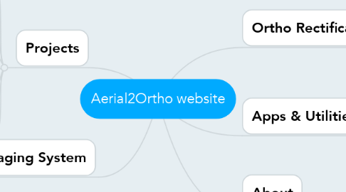
Aerial2Ortho website
by Ashish Masih


1. Projects
1.1. Overview of all projects
1.2. Yellowstone National Park
1.3. Salt Lake Wetlands
1.4. Gila River Survey
1.5. Escalante River Survey
1.6. Dinosour Park
1.7. Cibola Bird Refuge
1.8. CA Vineyards
2. Imaging System
2.1. MS system
2.1.1. 4x cameras
2.1.2. MS recorgind system
2.1.3. Time tag from GPS reciever
2.2. GPS
2.2.1. GNSS antelnna
2.2.2. Novatel GPS receiver
2.2.3. IMU (Inertial Measurement Unit)
3. Ortho Rectification & Image Processing
3.1. MicroStation
3.2. PhotoMod
3.3. PhotoScan
3.4. ArcMap
4. Apps & Utilities
4.1. Tiff Tag Renamer
4.2. UTC Tiff Time Correlator
4.3. Gdal Batch Commander
4.3.1. Raster to Shape File
4.3.2. 32 bit to 16 bit conversion
4.3.3. no data specify
4.3.4. Untitled
4.4. Gdal
4.4.1. Virtual Mosaic

